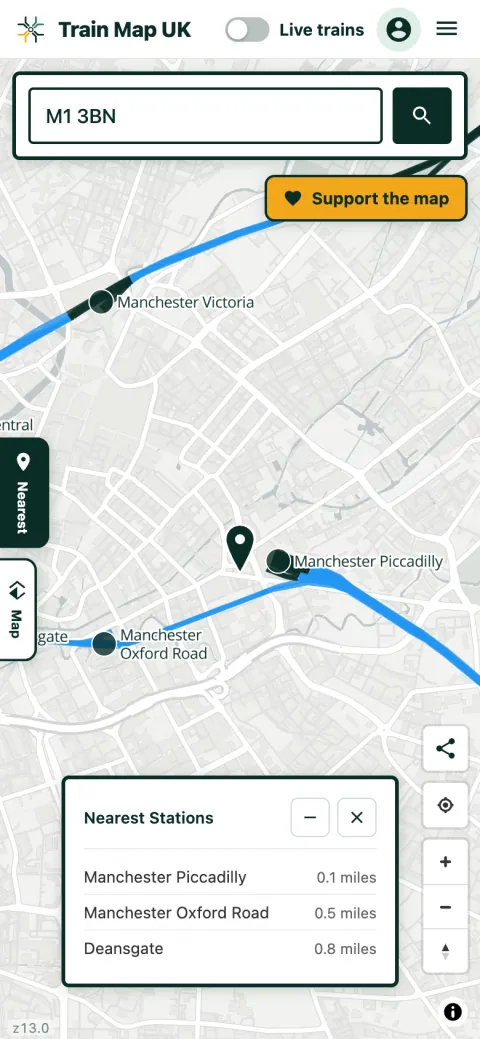
Your three nearest stations, ranked
Type a postcode and the map flies to it, drops a marker, and opens a panel listing the three closest railway stations in order, each with its distance. Tap any station on the map for its name, a link to its Wikipedia article, a live departure board and its location on Google Maps.
The panel can be minimised once you've got your answer, so it never gets in the way of the map underneath.
Stations near you, not just near a postcode
You don't need to know your postcode. Searching a town or village name works the same way, and so does a station name or its three-letter code (PAD for London Paddington, YRK for York, EDB for Edinburgh Waverley). Whatever you search, the nearest-stations panel updates to match.
How the distances are worked out
Distances are straight-line, measured from the centre of your postcode to the station. That is not the same as walking or driving distance, which will always be a bit longer, and occasionally a lot longer where a river, a railway or a motorway sits in between with no crossing nearby. Treat the figure as a good guide to which station is genuinely closest, then check the route itself for the journey.
Which stations count
The search covers all 3,235 railway stations currently open across Great Britain and Northern Ireland, and 2,601 of them carry a National Rail station code. Heritage railway stations are included, which matters if you live near a preserved line and want to know it's there.
Trams, light rail and the London Underground sit on their own separate layers rather than in the main results, so a search in a city doesn't fill up with tram stops before it reaches the mainline station you were actually after. Switch those layers on in the key whenever you want them.
Frequently asked questions
How do I find my nearest train station by postcode?
Enter any full UK postcode in the box above. The map jumps to that location and lists the three closest stations with the distance to each.
How is the distance measured?
Straight-line from the centre of your postcode, not walking or driving distance.
Which stations are included?
Every railway station currently open in Great Britain and Northern Ireland, heritage lines included. Trams, light rail and the Underground have their own layers.
Is it free?
Yes, free to use with no ads and no sign-up needed.
Once you've found your station
Once you've found your station, you can watch live trains moving through it in real time, or look at what used to be there: closed and former stations and disused lines often sit right alongside the railway you still use. There may be a heritage railway nearer than you think, too.